


During our recent weekend in London with Steven and Sherry I decided that the Navigation App on my phone wasn’t particularly user friendly, and so I’ve been trying out some alternative mapping apps. I discovered ViewRanger, and tried it out on a dog walk. It seemed quite good, with detailed maps that included contours. The only problem seemed to be with the GPS, which didn’t seem to following my location as I walked.
I walked up Croft Hill, knowing that my location should have moved across the contours as I ascended, getting closer to the smallest circular contour around the top of the Hill. When I got to the top, my location on the map should have been in the middle of this circle, but it remained stubbornly near the bottom of the Hill.
It wasn’t until I switched to satellite view that I realised that the small circular contour didn’t represent the top of Croft Hill. It represented the bottom of Croft Quarry. And my GPS location wasn’t at the bottom of the Hill; it was at the Quarry edge. That could have been embarrassing for a stranger using their phone to climb the Hill on a dark foggy night……
I think I will stick to big paper maps, and keep practicing with Navigation App.
 Technically we live in Oaktree House, but sadly the tree had to go.
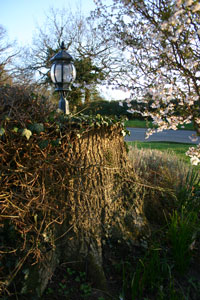
We now have a thriving Oakstump at the front of the house.
Technically we live in Oaktree House, but sadly the tree had to go.
We now have a thriving Oakstump at the front of the house.